BIM, or Building Information Modeling, transforms construction and engineering projects by integrating data for planning, design, construction, and management. This comprehensive approach improves project visualization and coordination, making decision-making easier and reducing risks. In this blog, we’ll delve into the essential software components of BIM, including 3D modeling, data management, and collaborative tools.
We will explore the modeling process and how BIM allows accurate digital representations of buildings and infrastructure. We will also discuss the various benefits of BIM, such as increased project efficiency, improved collaboration among stakeholders, and better resource utilization. Furthermore, we will look at real-world applications of BIM models across industries, including architecture, engineering, construction, and facility management. Additionally, we will highlight popular BIM software tools and examine emerging trends shaping the future of construction technology.
What is BIM Software?
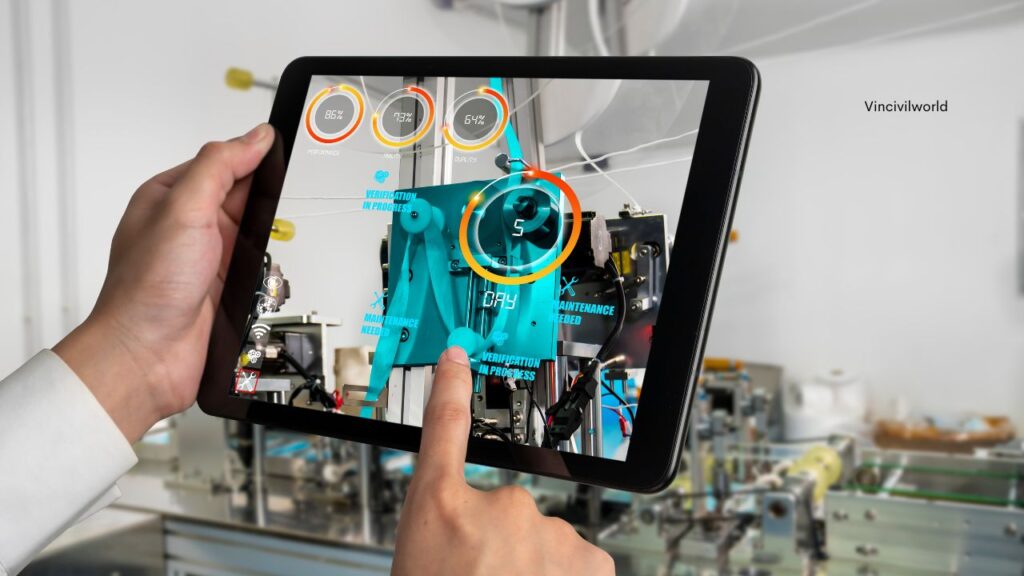
BIM software integrates data for planning, design, construction, and management of buildings and infrastructure. It creates 3D models that simulate construction processes and lifecycle management. Consequently, this software improves collaboration among architects, engineers, and contractors, thereby enhancing project efficiency. Moreover, it allows real-time updates and data sharing, ensuring all stakeholders work with current information.
BIM software enables visualization of building components and systems before construction begins. It includes tools for cost estimation, scheduling, and clash detection to prevent errors. Additionally, the software supports sustainable design practices by analyzing energy usage and environmental impact.
Furthermore, BIM enhances communication through visual representations and virtual walkthroughs. This facilitates decision-making based on accurate, detailed information. Moreover, BIM software evolves with technological advancements, incorporating cloud computing and mobile accessibility. Consequently, this fosters flexibility and accessibility across project teams and locations. Overall, BIM software transforms traditional construction processes by digitizing workflows and optimizing project outcomes.
Building Information Modeling: How It Works
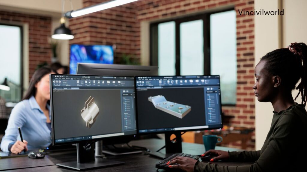
Building Information Modeling (BIM) begins with collecting project data and requirements. Architects, engineers, and contractors then work together to create a digital 3D model of the building or infrastructure, encompassing architectural, structural, and MEP systems. BIM software allows for detailed information to be added to model elements, including dimensions, materials, and performance characteristics. As the model progresses through different design and development stages, it integrates input from various disciplines for coordination and clash detection.
Changes and updates are made in real-time across the model. BIM facilitates simulations for analyzing construction sequences and logistics, supports visualization of project phases and milestones, and serves as a central database for project information and documentation. BIM models aid in cost estimation, scheduling accuracy, and improving project efficiency while reducing risks during construction. They foster better communication among project stakeholders and enhance client understanding through visual representation and virtual walkthroughs. BIM modeling transforms how construction projects are planned, designed, and executed with enhanced precision and collaboration.
Understanding BIM Models/Objects
BIM models are digital representations of entire buildings or infrastructure projects, including architectural, structural, and MEP (mechanical, electrical, plumbing) components.
BIM objects are individual elements in BIM models, like doors, windows, and equipment. They include detailed information such as dimensions, materials, and performance characteristics.
Both BIM models and objects facilitate accurate project visualization, collaboration among stakeholders, and efficient management of construction data.
Benefits of Building Information Modeling
BIM has many advantages in construction and engineering. It improves coordination, reduces errors, and enhances decision-making, making it a valuable addition to your projects.
- BIM improves project coordination and efficiency with precise digital representation.
- It improves collaboration among stakeholders with real-time data sharing.
- BIM reduces errors and clashes during design and construction phases.
- It facilitates better decision-making with detailed cost, schedule, and performance information.
- BIM supports sustainability by analyzing energy use and environmental impact early in design.
- It enhances construction quality and safety by simulating construction sequences and identifying risks.
- BIM serves as a centralized repository for project information, aiding documentation and facility management.
These benefits streamline workflows, reduce costs, and significantly improve project outcomes.
How Building Information Modelling Can Help You
BIM, or Building Information Modeling, offers numerous advantages for construction projects. It streamlines processes, enhances collaboration, and improves decision-making. Here are some key ways BIM can help you:
- Improve project coordination and collaboration.
- Integrate data from all project stages.
- Reduce errors and enhance decision-making.
- Provide detailed visualizations to identify and resolve issues early.
- Aid in better project planning and scheduling.
- Support cost estimation and budget management.
- Promote sustainability by analyzing energy use and environmental impact.
- Enable real-time data sharing to keep all stakeholders informed.
- Enhance overall project efficiency.
- Reduce risks and improve the quality of construction projects.
These benefits make BIM an invaluable tool for the construction industry.

Applications of Building Information Modeling
BIM, or Building Information Modeling, has wide-ranging applications across the construction and engineering industries. It enhances project efficiency, improves collaboration, and supports sustainable practices. Here are some key applications of BIM
- Design Visualization: Create 3D models to visualize the project and design elements before construction.
- Construction Planning: Optimize construction sequences and logistics for better efficiency and resource management throughout the project lifecycle.
- Cost Estimation: Provide accurate cost estimates and manage budgets by integrating data from various project stages and elements.
- Facility Management: Support maintenance and operations with detailed and up-to-date building data for better facility management.
- Sustainability Analysis: Analyze energy use and environmental impact to promote sustainable design and construction practices.
- Clash Detection: Identify and resolve conflicts between architectural, structural, and MEP systems before construction starts, preventing costly errors.
- Structural Analysis: Perform structural simulations and load assessments to ensure the integrity and safety of building designs.
- Project Coordination: Enhance collaboration among architects, engineers, and contractors by enabling real-time data sharing and communication.
- Safety Management: Improve site safety with risk simulations and safety planning integrated into the construction process.
- Documentation: Centralize project documentation and manage data efficiently, ensuring easy access and updates for all stakeholders.
BIM in Different Industries
BIM, or Building Information Modeling, is revolutionizing multiple industries by improving efficiency, collaboration, and project results. In architecture and construction, BIM enables detailed 3D modeling, enhancing design accuracy and visualization. It also simplifies project planning, cost estimation, and construction management, reducing errors and delays.
In engineering, BIM combines data from different disciplines to improve coordination among structural, mechanical, electrical, and plumbing systems. This integration results in more efficient designs and makes it easier to detect potential clashes.
BIM brings improved project management to the infrastructure industry, benefiting roads, bridges, tunnels and industrial structures. It enhances planning, construction, and maintenance processes, ensuring projects are completed on time and within budget.
In real estate, BIM helps with property management by offering detailed building data and enhancing maintenance. It also promotes sustainable building practices by analyzing energy efficiency and environmental impact.
Manufacturing industries use BIM for designing and managing production facilities. It enables better layout planning and integration of complex systems, increasing productivity and reducing operational costs.
Healthcare facilities benefit from BIM by improving design and management of hospitals and clinics, optimizing space utilization, enhancing patient flow, and supporting maintenance and operations.
Overall, BIM’s application across different industries revolutionizes traditional processes, enhances collaboration, and delivers better project outcomes.
Overall, BIM’s application across different industries revolutionizes traditional processes, enhances collaboration, and delivers better project outcomes.
Popular Building Information Modeling Software Tools
Building Information Modeling (BIM) software tools are essential for modern construction and engineering projects, improving efficiency and collaboration. Some popular BIM software tools include:
Autodesk Revit
One of the most widely used BIM tools, Revit supports multi-disciplinary design processes easily. It enables architects, engineers, and contractors to collaborate within a single, integrated model. Additionally, Revit provides robust tools for 3D modeling, clash detection, and comprehensive construction documentation.
Navisworks
Navisworks is utilized for project review and coordination. It integrates with different design tools to offer a comprehensive view of project data. The software is highly effective for clash detection, 4D simulation, and project scheduling.
ArchiCAD
Developed by Graphisoft, ArchiCAD is known for its user-friendly interface and powerful design capabilities, making it popular in the architecture community. It allows architects to create detailed 3D models and supports collaborative workflows.
Tekla Structures
This software is well-known for its strong structural engineering features, enabling users to create detailed 3D models of steel and concrete structures. It covers the entire construction process from design to fabrication.
Bentley Systems
Bentley provides BIM tools like MicroStation and OpenBuildings Designer, widely used in infrastructure projects for detailed design and analysis. These tools support collaboration across disciplines and ensure project accuracy.
Vectorworks
Vectorworks provides comprehensive tools for design and BIM workflows. It is suitable for various disciplines, including architecture, landscape, and entertainment design. The software integrates 2D and 3D design capabilities, making it versatile for different project needs.
Autodesk BIM 360
This cloud-based BIM tool enhances project collaboration by providing a platform for data sharing and management. It supports project coordination, document management, and construction field management, ensuring that all stakeholders have access to the latest project information.
These BIM software tools enhance project efficiency, improve coordination, and ensure the accuracy of construction projects. They are essential for modern construction and engineering workflows.
Future Trends in BIM
The future of BIM is being shaped by emerging trends that greatly enhance its capabilities and broaden its applications. One major trend is the integration of artificial intelligence (AI) and machine learning, which can automate complex tasks, optimize designs, and predict project outcomes with greater accuracy and efficiency. Furthermore, advancements in cloud-based BIM platforms are revolutionizing project collaboration by enabling real-time data sharing and effective coordination among stakeholders.

The growing use of cloud-based BIM platforms enables real-time collaboration among stakeholders, regardless of location, which enhances efficiency and decision-making.
The use of augmented reality (AR) and virtual reality (VR) in BIM is increasing. These technologies allow immersive project visualization and interactive design reviews, leading to higher stakeholder engagement and fewer errors.
Sustainability is a key focus, with BIM tools increasingly incorporating environmental impact analysis. This supports greener building practices and compliance with sustainability standards.
Finally, the integration of BIM with Internet of Things (IoT) devices is on the rise. IoT sensors provide real-time data on building performance, providing better facility management and maintenance.
These trends highlight BIM’s increasing role in creating smarter, more efficient, and sustainable construction practices.
Potential Challenges or Limitations of BIM
Challenges of Implementing BIM:
- High Initial Costs: Using BIM requires a lot of money for software, hardware, and training, which can be hard for smaller companies.
- Learning Curve: People who are used to traditional methods may find it difficult and time-consuming to learn BIM tools and processes.
- Data Management: Handling large amounts of data from BIM models requires strong data management, which can be complex and resource-intensive.
- Interoperability Issues: Different BIM software tools may not work well together, causing potential issues with data compatibility and collaboration.
- Resistance to Change: Some professionals may not want to use BIM because they prefer traditional ways of working and don’t like changing how they do things.
- Legal Challenges: Figuring out who owns, is responsible for, and has rights to BIM data can lead to legal problems and complications.
- Maintenance and Updates: Keeping BIM software up to date and working well requires ongoing resources and commitment.
- Stakeholder Collaboration: Getting everyone involved to work together effectively is really important for BIM to succeed, but it can be hard to coordinate efforts and communicate well.
Key Takeaways
Building Information Modeling (BIM) transforms construction and engineering projects by integrating data for planning, design, construction, and management. It improves visualization, collaboration, and decision-making while reducing risks and errors. BIM is used in architecture, engineering, infrastructure, real estate, manufacturing, and healthcare, offering benefits such as improved coordination, resource utilization, and sustainable practices. Popular tools include Revit, Navisworks, ArchiCAD, Tekla Structures, Bentley Systems, Vectorworks, and Autodesk BIM 360. Emerging trends in BIM, such as AI, cloud-based platforms, AR/VR, sustainability, and IoT integration, are shaping its future.
Conclusion
Building Information Modeling (BIM) is revolutionizing the construction and engineering industries by digitizing workflows and optimizing project outcomes. It offers a comprehensive approach to project management, from design and planning to construction and maintenance. Advanced technologies such as AI, machine learning, AR, and VR enhance BIM’s capabilities, leading to more efficient projects and reduced risks. While there are high initial costs and a need for substantial training and data management, the benefits of BIM in improving collaboration, reducing errors, and promoting sustainable practices are significant. As the industry evolves, BIM’s role in creating smarter, more efficient, and sustainable construction practices will become more prominent. Embracing BIM and staying updated on its trends and advancements can result in significant improvements in project outcomes and industry innovation.